


Descripción de OSM Peak Finder
The app is programmed just for fun in free time with no commercial purpose. The feedback is always welcome as well as any suggestions for improvements.
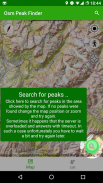
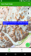
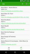
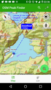
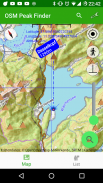
The main functionality is to present the mountain peaks near your location. Using the bearing line, which is showed starting at your location, you will be able easily to localize and identify peaks around you.
The map tails can be pre-loaded as well as the peak's information, so it should also be possible if you are online, assumed you loaded it before being online.
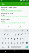
With the seek bar you can also filter out peaks starting with certain elevation.
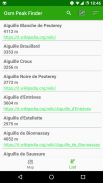
You can also show the list of the surrounding peaks and e.g. sort them by elevation or name. In the list you will also additional information such as link to Wikipedia, if available or disability access.
Have fun using it and let me know if you like it.
La aplicación está programada solo por diversión en el tiempo libre sin fines comerciales. Los comentarios siempre son bienvenidos, así como cualquier sugerencia de mejora.
La funcionalidad principal es presentar los picos de las montañas cerca de su ubicación. Usando la línea de demora, que se muestra comenzando en su ubicación, podrá localizar e identificar fácilmente los picos a su alrededor.
Las colas del mapa se pueden cargar previamente, así como la información del pico, por lo que también debería ser posible si está en línea, suponiendo que lo cargó antes de estar en línea.
Con la barra de búsqueda también puede filtrar picos que comienzan con cierta elevación.
También puede mostrar la lista de los picos circundantes y, p. ordenarlos por elevación o nombre. En la lista también encontrará información adicional, como un enlace a Wikipedia, si está disponible o acceso para discapacitados.
Diviértete usándolo y avísame si te gusta.
OSM Peak Finder - Versión 1.02.67
(25-02-2024)OSM Peak Finder - Información de APK
Version de la app: 1.02.67Paquete: eu.wuwer.osmpeakfinderApps en la misma categoría
Quizá también te interese...


